
The long range forecast seem to have depressions rolling in on a 3 day frequency, 16th, 19th and 22nd Nov. Each tracking higher that the previous with the last missing most of England and Wales
Heavy weather forecasted for the UK tonight? 1987 again
-
Dave in Warrington
Re: Heavy weather forecasted for the UK tonight? 1987 again
The southern coast got the worst of the stormy weather. Nothing much here yet 
The long range forecast seem to have depressions rolling in on a 3 day frequency, 16th, 19th and 22nd Nov. Each tracking higher that the previous with the last missing most of England and Wales
The long range forecast seem to have depressions rolling in on a 3 day frequency, 16th, 19th and 22nd Nov. Each tracking higher that the previous with the last missing most of England and Wales
-
stephenprudence
Re: Heavy weather forecasted for the UK tonight? 1987 again
That should be a  Dave, because that higher track means we'll be pulling in much milder air all the time.
Although it might been we get the worst winds at one point.
Although it might been we get the worst winds at one point.
-
Exotic Life
Re: Heavy weather forecasted for the UK tonight? 1987 again
Beaufort 6-7 for a long time here now, just curious if I get some real wind gust later this evening when the "trog" is passing.
Robbin
Robbin
-
Dave in Warrington
Re: Heavy weather forecasted for the UK tonight? 1987 again
True, that should have been a 'Thumbs up'stephenprudence wrote:That should be a
Although it might been we get the worst winds at one point.
If the depressions are tracking between the UK and Iceland, we couldn't ask for better winter weather here. A nice Mild south westerly and 'less stormy' than of late.
However we do have the first two tracking over the UK it would seem from the forecast
-
Dave Brown

- Site Admin
- Posts: 19742
- Joined: Sun Jul 09, 2006 10:17 am
- Location: Chalk, (Thames Estuary) Kent, England 51.5N 0.3E
- Contact:
Re: Heavy weather forecasted for the UK tonight? 1987 again
That is one of the advantages of living in the extreme Southeast. There aren't manyDave in Warrington wrote: If the depressions are tracking between the UK and Iceland, we couldn't ask for better winter weather here. A nice Mild south westerly and 'less stormy' than of late.
However we do have the first two tracking over the UK it would seem from the forecast
Seriously, we very often stay south of the cold fronts when we get a succession of depressions, but as we are nearer the high than the low, get mild, fair weather.
Best regards
Dave
_________________________________________________
Roll on summer.....
http://www.hardytropicals.co.uk
Dave
_________________________________________________
Roll on summer.....
http://www.hardytropicals.co.uk
-
Exotic Life
Re: Heavy weather forecasted for the UK tonight? 1987 again
Well I use this topic again for the Estofex forecast. Big part Level one forecasted for later today and tonight.
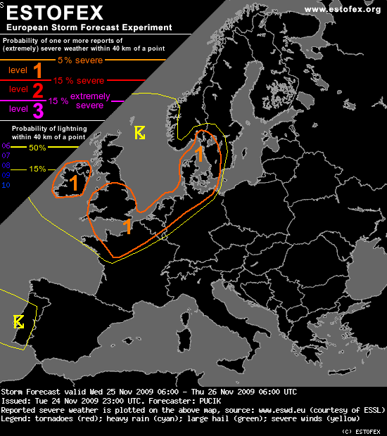
DISCUSSION
...England, Northwestern France, BENELUX, N Germany, Denmark, SW Sweden...
Strong cold front will make its way across the region. Ahead of the front, very strong flow will be present, veering from southerly to south-southwesterly direction with height. At 925 hPa windspeeds above 20 m/s are anticipated and at 500 hPa, values will vary between 40-50 m/s. Models are predicting a belt of enhanced SREH values both in 0-1 and 0-3 km layer. Due to the above mentioned facts, favorable kinematic setup is in store with wind shear values above 40 m/s in 0-6 km layer and from 10-15 m/s in 0-1 km layer.
Strong mesoscale ascent is anticipated in the frontal region and high PV values are advected at upper levels behind the front. One of the detrimental factors to the situation will be a lack of well-developed latent instability. Both GFS and ECMWF predict very marginal values of CAPE, around 200 J/kg in the vicinity of the front. But frontal ascent can at least a bit compensate for the instability. There is a slight chance that with strongly forced convection, meso or misocyclonic circulations manage to develop with attendant threats of severe wind gusts and tornadoes. Due to these threats, Level 1 is issued.
... Ireland, Northern Ireland, Wales, Western England...
In the post-frontal environment, cold mid-levels combined with relatively warm SSTs lead to the marginal destabilisation of the maritime polar airmass. CAPE values around 500 J/kg are expected, mostly over the sea, but models simulate certain values of CAPE also inland. Due to the strong flow at lower levels of troposphere, strong windshear at 0-1 km is forecast, with values up to 15 m/s. Enhanced SREH is also simulated, due to the ageostrophic flow component due to the friction. Slight chance of tornadoes will exist as well as marginally severe wind gusts with stronger convection.
-
Dave Brown
- Site Admin
- Posts: 19742
- Joined: Sun Jul 09, 2006 10:17 am
- Location: Chalk, (Thames Estuary) Kent, England 51.5N 0.3E
- Contact:
Re: Heavy weather forecasted for the UK tonight? 1987 again
I have to go out in the next few minutes to make some temporary repairs to my covered bit roof which still has a panel missing ripped off on Monday. In it's present condition the hole may well allow other panels to be ripped off. and I'll end up with an uncovered covere bit 
Best regards
Dave
_________________________________________________
Roll on summer.....
http://www.hardytropicals.co.uk
Dave
_________________________________________________
Roll on summer.....
http://www.hardytropicals.co.uk
-
Dave in Warrington
Re: Heavy weather forecasted for the UK tonight? 1987 again
It was turbulent earlier when the weather front passed but not as bad as indicated.
You've a similar senario as losing a tile on the house roof Dave,
1 comes off, the wind gets in and then half the roof goes
You've a similar senario as losing a tile on the house roof Dave,
1 comes off, the wind gets in and then half the roof goes